Roadtrip to Yellowstone
Usa
21 June 2022
Roadtrip to Yellowstone
States: NY, Nj, PA, OH, IN, IL, WI, MN, SD, WY, MT, NE, IA
Miles:
8 Days
June 19-26, 2020
My first trip to Yellowstone I left New York June 19, 2020. My first day destination is the third largest city in America, Chicago. I used Interstate 80, as it was the most obvious, as it completely drives to the largest city in the state of Illinois, hometown of Al Capone. I stayed here in a small hotel in the suburbs,but like every time, I went to explore the city. Since this wasn’t my first time here, I was able to easily to get around and walk trough main sights of Chicago. I won’t even describe the city right now, and then you can read a little more about it at the Chicago page.
Early the next morning, after a good coffee and a quick refuel, I continued my journey to west on the I-90. Today’s plan was to reach Rapid City, SD. There was no problem on the long journey. Out of Chicago, the highway toll booths were as free, anyone could cross for free because there were no employees at the cash gates due to the covid epidemic. Nothing significant or notable has happened so far. My car is running very well, which is a luxury version of a 2015 Toyota Sienna minivan. I prepare before every major trip. If necessary, new wheels, new brakes and oil change before every single road trip
are essential. When I reached the Mississippi River, which is the border river between Wisconsin and the state of Minnesota, I stopped at a resting place on by the side of the river.Here you will find a clean, tidy restroom and all the necessary tourist information, such as maps and brochures and free books. I wasn’t in such a hurry, I looked at the famous Mississippi River itself, which is the longest river in America. I lingered a bit, and before I set off, I took some photos with a Minnesota state welcome sign. Traversing Minnesota, I reached the state of South Dakota, which was still characterized by a dull, mostly
agricultural landscape. I knew from my trip in 2002 – when I drove all the way to California-, that the Missouri River, roughly halfway through the state, was starting to get more interesting because the landscape was changing here. Soon arrived here, and because of the beauty of the area, we stopped here in the stop lane at the edge of the highway for a few photos, as the view was stunning after a long and boring plain. Standing on a hilltop, we were able to look at the Missouri River Valley and the bridge that crossed it, and then the lower, hilly green landscape beyond the shore. But by the time we got in the car,the Sheriff was about to stop behind us, and we set off quickly and went out the first exit. But wherever we turned, the Sheriff came after us. I knew he was going to stop now, the only question was when. We stopped in the parking lot of a small shopping mall where there were restaurants and shops because we wanted to buy food and coffee. Then I see in the mirror that the Sheriff has also stopped behind us with a Dodge SUV. Then he got out of his car and walked over to us. He was a young, incredibly kind man who just warned me that the next time if I want to stand and admire the landscape, there was a lookout on the other side of the highway that was made for that purpose. Then I wish you another pleasant trip, we also thanked the information and the sheriff went into the restaurant. Then it turned out that he also went to the mall to have lunch with his family, which is probably why he followed us so far.
Mt. Rushmore
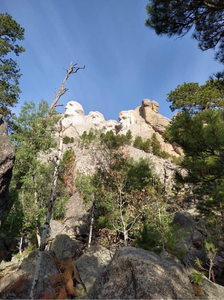
Then I continued our journey to Rapid City, where we arrived late that evening. Rushmore The next morning, after a short breakfast, I went to Mount Rushmore. Leaving Rapid City, the American Monument is about 45 minutes from the city. As I approach Mt. Rushmore, the landscape has become more beautiful. The combination of valleys covered with pine forests and fields is a wonderful sight.
Once upon a time, millions of bison visited this area and their march was followed by the tent camps of the Indians. No wonder they fought so much for the countryside. As I approach the national monument,the heads of the presidents in the rocks are already visible from a distance.Portraits of Gorge Washington, Thomas Jefferson, Theodore Roosevelt and Abraham Lincoln adorn the sides of the rocks.
This monument was started in 1927 and their work lasted until 1941. The idea of the historian Doane Robinson aroused the interest of the sculptor Gutzon Borglum. But it didn’t matter what kind of monument was made here, since the Black Hills, where Mt. Rushmore is also located in the Great Sioux Nation Reserve, was located under the original arrangement. This agreement was violated by the U.S.government after gold was found in the Black Hills area.Robinson’s original idea was to have figures of American Wild West heroes carved out of the rock, like Lewis and Clark, and their leader Sacagawea,who cut him a handful of exploration trips on behalf of the U.S. government to find the east and west coasts. gateway. They nearly lost their lives on the road, but in the end, after so many attempts, they were successful at first. But there would have been statues of Red Cloud, Buffalo Bill Cody, Crazy Horse in the wall. Borglum decided he would rather carve a portrait of four presidents.
Of the several possibilities, the small image, that is, the model of the large original, was finally completed, and thus the four presidents named above remained, which we can still admire to this day. There were other reasons for Borglum’s
decision, not only that he did not agree with Robinson’s idea, but that the material of the rocks would not have been adequate to carry out the original idea. Even so, the statues on Mount Rushmore require regular maintenance. Either way, work began in 1927 and was stopped in 1941, but the work remained unfinished, which is likely to remain so now. The model of the project shows what it would have been like if the whole work had been successfully completed, which can be viewed in the museum below the mountain. And in the other building next to the museum, we can see the huge compressor that pushed the air pressure to the top of the mountain to the jackhammer. Then,walking down the wooden stairs along
the footpath next to the museum, we can get quite close to the bottom of the statues. After admiring the national monument (myself for the second time, first in 2002), we went on to the Crazy Horse Monument,which is about 30-40 minutes away. Crazy Horse Admission is not cheap and does not cover the way to see the Crazy Horse Monument. Anyway, it’s not really worth it, since the monument of the Indian chief is not even half way finished and,according to the tour guide, the works will take about another 80 years.But the size difference between Mt. Rushmore and Crazy Horse is impressive. The Indian statue sitting on a horseback and pointing forward will not be carved into the rock, but the rock itself will be the statue.
The size of this should be imagined as just the size of the pointer as a U.S. school bus that roughly matches the size of an school bus.According to the tour guide, workers live up there and only come down when it’s lightning and it’s too cold. They deliver food, tools, dynamite and everything else they need. A Hungarian friend of mine is the sculptor Peter Wold Toth, who has also worked with the Cherokee Indians for 15 years on the Crazy Horse statue. But here, too, let me tell you an interesting story related to this place …
Crazy Horse Lakota Chief Chief (circa September 5, 1840-1877) who is not only a chief but also the warlord of his people, whose father was the son of the “medicine man,” or Indian shaman, won several wars for the Indians against the army. Accompanied by Crazy Horse and other Oglala leaders, he arrived at the so-called Red Cloud Agency, which was not far from Robinson Fortress in Nebraska. On May 5,1877, accompanied by He Dog, Iron Crow, and Little Big Man, he appeared here to formally lay down their arms and surrender. Attention from the U.S. military to Crazy Horse has made Red Cloud and Spotted Tail jealous, as they have long lived with the Red Cloud Agency. These two began to spread lies about Crazy Horse that Crazy Horse wanted to return to his old way of life and thus jeopardize the fragile peace he had with the U.S. military. Then, in August 1877, news arrived from Fort Robinson officers that Chief Joseph had erupted from the reserve around Nez Mince in the state of Idaho and had fled to Canada via the state of Montana. Lieutenant Clark then asked Crazy Horse and the other Native American leaders to help them join the U.S. Army, but Native American leaders opposed it. Then Crazy Horse finally agreed and said, “I’ll go up north and I’ll fight until no Nez Perce survives,” but the translator, a half-Tahitian scout, either misunderstood or deliberately turned him over because he said back officers that Crazy Horse’s response was, “I’ll go up north and fight as long as no white man survives.” Of course, the tension was growing. Then, due to increasing problems at the Indian agency, General George Crook was ordered to stop at Fort Robinson, which happened. Upon his arrival, General Crook was mistakenly informed that Crazy Horse wanted to kill him, before Crook understandably ordered Crazy Horse’s arrest and then left the fort. Briefly, on the morning of September 5, 1877, Lieutenant Crazy Horse and Lieutenant Lee, accompanied by some Indian scouts, set out for Fort Robinson. Upon their arrival,Lieutenant Lee was informed here that he would have to hand over Crazy Horse to the daily officer as he was under arrest. Lee protested and hurried to Bradley’s accommodation to discuss the issue, but in the meantime they wanted to escort Crazy Horse and Little Big Man to the prison. When Crazy Horse and the Indians realized what was going on, they tried to escape and then stabbed Crazy Horse twice in the back with a bayonet, and then the third punch didnt hit him, but it just hit the door. But even that was enough for the last great Indian leader to die in the same evening. The young Crazy Horse, who was one of the greatest Indian warriors ever lived, but if he was the greatest, was honored even by the U.S. Army. He had no desire, asked for nothing else from the U.S. government in exchange for laying down his gun, just let him hunt freely in the Black Hills. He had to die due to a misunderstanding. But Crazy Horse knew he wouldn’t die in war. That’s why he wasn’t afraid to fight. He won battles like Little Big Horn, where the U.S. Army led by General Custer was crushed. Crazy Horse knew he would survive every battle, as an Indian fortune teller predicted he would not die in war, and if he died, he would return to earth in stone
form. And I see…
Allegedly, the door of this Fort Robison building where Crazy Horse was killed shows the location of the lost third bayonet to this day.After shopping at the Native American Museum store, where you can get great Native American stuff at a good high price.
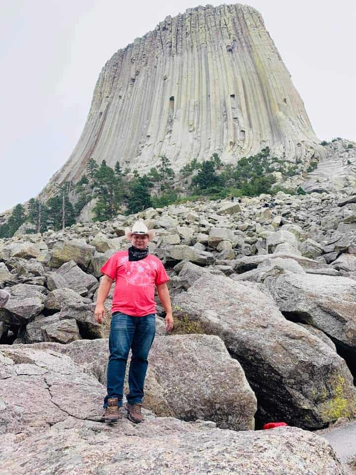
Devil’s Tower
I headed to the Devil’s Tower, a huge rock called Devil’s Tower known for its Type 0 encounters. This is already the state of Wyoming. On the way We walked past city of Sundance, where Sundance Kid earned his name is the local jail. He portrayed his figure in Robert Redford’s 1969 film “Buch Cassidy and the Sundance Kid.” One of the curiosities of the settlement is that it is surrounded by a wire fence. But we left the settlement now, and then we went down the grassy steppes of the prairie to a small road, where the environment became more and more hilly, and then from a hilltop approx. Half an hour away you can see the huge rock in the prominent national park, the Devil’s Tower. When we got there,there was a huge line in the gate waiting for them to get in. The fellow travelers decided they didn’t want to go in,instead they took some memorabilia, then photographed the mountain in the distance and continued on our way to Yellowstone National Park. Along the way, we saw settlements inhabited by Native Americans living in residential chocolates, in a puritan, dirty environment. The sight of the running dog dogs was refreshing,and then we soon saw a roadside sign about a former fortress. We decided to check this out, it would fit our time. We could see the remains of Fort Philips Kearny, next to I-25, and try to learn its history. As we arrived we saw a fortified wall made of large sharpened wooden beams with lockable windows.
As we crossed its gate,we saw that there was not much left of the once huge fortress. The large grass is more than just signs indicating what buildings existed within the fort. There was everything here, a blacksmith,a weapons depot, a barn, barracks, even a grocery store and a bakery. The four towers of the fort were rebuilt for interest. Then we saw the place of the sentry on the distant mountain, which was a terribly great distance from the fort. We then became aware that at the scene of the Native American attack, a group of sculptures made of sheet metal or plywood by an attacking Native American sculpture were resurrected on the side of the hill, depicting a Sioux Native American attack that actually took place here 15O year ago. We were convinced that the Indians had destroyed the fort to dust. On my second trip to Yellowstone at Fort Kearny in Nebraska, an American patriot told me the story of that fort:
Forth Phil Kearny
Forth Phil Kearny The tragic events surrounding Forth Phil Kearny and the Fetterman Massacre, as well as the Wagon Box Fight, are one of the most dramatic chapters in the history of Native American wars.For two bloody years, between 1866 and 68, the Sioux Indians bitterly opposed the invasion of their hunting grounds through the Bozeman Trail to the gold miners who made their way to the gold meadows of Montana. The events that took place here were one of the few Native American wars in which the U.S.military was forced to leave the region it occupied. It so happened that gold was found in the state of
Idaho in 1868, and then gold was found and flooded in the western mountains of Montana from all over.A large portion of these arrived in Virginia City. The following spring, John M. Bozeman and John M.Jacobs established the Bozeman Trails, or routes, for the sake of walkability and commerce. Some of these roads connected the Fort Laramie trail from Wyoming to Oregon through the Bighorn Mountains to Fort C.F. Smith Fortress touching Virginia City. Gold diggers soon began pouring in on the path that led through the heart of the Indian hunting grounds. In addition, the Sioux Indians recently captured these territories from the tribe of the crow. The Sioux people soon realized that those passing through here could not defend themselves, for in the absence of the military, these travelers had no protection. Taking advantage of this, hell soon escaped.A little earlier, in 1865, at Fort Sully Fort in South Dakota, the government contracted a small Sioux boss.In return for an annuity, they agreed to withdraw from the vicinity of the emigrant routes and not attack them. The mistake was that these commissioners only dealt with the leaders of the tribes along the Missouri River, and those who really didn’t. The Red Cloud, Man Afraid of His Horses, and other bosses who visited the Powder and Bighorn areas vowed not to let any travelers go undisturbed. In the late spring and summer of 1866, an American commission met with these leaders in Fort Laramie,Wyoming.
Colonel Henry B. Carrington and 7OO of the 18th Infantry enlisted in the fort. When the Red Cloud and other bosses learned that their mission was to build forts along the Bozeman Route, they left the conference and declared war on all the invaders in their country. Carrington fortified Fort Reno that summer and fall and built Fort Phil Kearney and Fort C.F. Smith forts. Sioux, Arapaho, and northern Cheyenne (sejen) fighters blocked the road and killed 154 people near Fort Phil Kearney from Aug. 1 to Dec. 31, then wounded another 2O. Those who approached it were regularly attacked and more than 75O
pets were destroyed or driven away. Even the strictly guarded supply trains had to deal with them. The forts were subject to constant harassment and the chariots carrying the material and the construction sites had to constantly repel the attacks. The Sioux efforts centered on the center of Carrington at Fort Phil Kearny Fortress, which was built in an area interspersed with streams called North Piney Creek and Little Piney Creek, located on a plateau about 5O-6O feet (15-2Om) above the river. Fort Phil Kearny was the largest of the three stops on the Bozeman Route and one of the safest western forests of the age. The fortress: construction began on July 13, 1866, and finally from 42 log houses, approx. The 6OO and 8OO feet long (2OOx 26Om) based fortress was surrounded by 11 feet of 3.5 meter high sharpened pine beam walls and protected at its corners by rectangular platforms or bastions. To protect this, Cavalry No. 2 strengthened Carrington’s infantry. Strong defenses were needed, although the Red Cloud did not prevent the fort from rebuilding, but soon kept the fort and its surroundings under constant siege. There were 21 women and children living in the castle who felt it from Fort Kearny in my state of Nebraska. A group of young officers who disliked and even looked down on Carrington, including Captain William J.Fetterman, were disobedient and boasted that they were riding with eighty people throughout the Sioux nation.
On December 21, 1866, a smaller Indian army attacked a timber-carrying convoy that would have brought a shipment to the fort. Carrington sent Fetterman and two other officers to assist the convoy with 48 infantry, 28 cavalry, and two polgra. A total of 81 men set out for him to save the consignment and the carriers from the attack by the Indians. Fetterman was warned not to cross the Lodge Trailt Ridge, where they would fall out of sight from the fort, but Fetterman let a small team of Native American warriors lure him north while the Red Cloud was already waiting for them beyond the ridge. In just half an hour,hundreds of Sioux, cheyenne, and araphao warriors attacked the lost army and slaughtered them to the last man. Auxiliary troops from the fort arrived too late to rescue Fetterman and his men. It was the biggest victory for the Pararie Indians so far in the U.S. Army, and it was soon followed by events like Little Big Horn. Following the Fetterman massacre, Carrington civilians were sent by John ” Portugee ‘Philips and Daniel Dixon to take the message to Omaha headquarters in connection with the disaster and to the
Hordeo Bend telegraph station near Laramie to forward the request for confirmation. John Philips covered
236 miles in a blizzard to reach Fort Laramie. In 1867 Carrington was replaced. This summer, the Indians closed the Bozeman route only strong military convoys could pass through it, but they also had to fight for it. The Sioux and Cheyenas agreed to shut down the forts from their sources and demolish Fort Phil Kearney and Fort F. C. Smith in Montana. On Aug. 1, Fort F.C. There was a bloodier clash near Smith,and the next day, between 1500 and 25OO, a siege and Cheyenne warrior, led by the Red Cloud, attacked an infantry of 28 people guarding civilian lumberjacks near Fort Phil Kearny. Most of the civilians
managed to escape, but four were trapped there with the soldiers in an oval barricade previously made of 14 overturned box chariots for protection. The soldiers had the latest Springfield rifles, which was very surprising to the Sioux and Cheyenne fighters. The rescue army soon arrived from the fort. The military reported two dead and two wounded, while the Indians put the number of fallen and wounded between 6O and 12O. In the middle of the castle, where a huge flag now stands, was a pit (according to the narrator),where gunpowder barrels and ammunition were kept. The women and children were rescued here with a soldier whose job it was for the soldier to blow up the gunpowder barrels if they could not resist the
Indian attack and they would break into the fort. They waited for days for the Indians to attack and the Americans knew that if an attack took place, they would by no means be able to hold the fort for long.But the Indians thought differently than the whites. They didn’t want to exterminate them, they thought they had taught the U.S. military a lesson, and now they’re definitely going to leave. Such was the life in American border castles.
After we got out of the fort, we continued on our way. From here it was no longer the 14 roads we had to turn onto and, passing by the Crazy Woman inn, we headed straight for the rocky mountains. Reaching the mountains steeply uphill, we were unable to stop making feeders from the plain below us. The view was so beautiful it couldn’t be filled with it. But we had to move on as the evening approached perilously.after we reached the top of the hill, we continued on a plateau, and here somewhere along the way we noticed that a moose was grazing alone among the bushes by the road. We stopped to observe as we all saw moose for the first time. As we continued on, coming from here into a gorge, we were surrounded by huge rock walls and a fast-lowing stream flowed along the road. The small stream that travels here,forming beautiful waterfalls, traverses through the strait, which becomes more and more beautiful. After leaving the strait, we saw more and more beautiful houses almost palaces moving towards the Yellowstone in the wilderness. It was already dawning on us when another moose passed through the dark road in front of us, it took a very strong brake to keep the poor away.
Cody
Cody We arrived in Cody sometime late at night. After we checked into the motel, we went out to see the town, which is the last town in front of Yellowstone National Park. We even went into a small village pub where the rodeo was over, but the cowboys were still drinking. It is so important to know about the city of Cody that the founder of the city was none other than the “Buffalo” Bill, that is, Colonel William Frederick Cody (1846-1917). Buffalo Bill passed through here in the 1870, when he liked the area, and then returned here in the 1890 to establish his own settlement along the Shoshone river. By the age of 41,Buffalo Bill had become one of the most famous people in the world. That was the “Wad West’s Way to Yellowstone.” the motel he founded is still in operation today. Kanye West also has a ranch here at Lake Ranch, also known as Monster Ranch.
Old Trail Town The next morning. Arriving at our main destination, we will explore Yellowstone National Park. But first let’s take a look at the town of Cody, and then one of our fellow travelers found a small western village on the outskirts of Cody, which is actually a village museum that we’ll definitely want to explore. Admission is $ 9 dollars, but every penny is worth it. This small Wild West settlement is made up of original houses from Gererna, brought here and assembled from different parts of the country.
Everything here is original, everything is real. rich wild west culture was condensed here. It was here that Buffalo Bill Cody founded the ancestor of the town of Cody in 1895, which he later moved to the city’s current location. Behind Old Trail Town you can see traces of the original settlement. Thanks to the founder of this museum, Bob Edgar, who recognized that these monuments left in the former wildlands are disappearing across the country and founded this village museum. So we saw today the house of a robber band called Buch and Cassidy and Wild Bunch and Sundance Kid, or the house of “liver eater” Jeremiah Johnson, who was also featured in Robert Redford’s “Jeremiah Johnson” and then when “liver eater” his grave was excavated and buried here again, the actor legend came to the funeral and was one of the coffin bearers. But we can find the Wild West Salon that Sundance Kid regularly visited with his outlaw team called “Hole-in-the-wall,” and the door shows bullet marks from a shooting to this day. Here was brought “Curly” the house of a crow Native American who was one of the Indian scouts who helped Brigadier General George Armstrong Custer and the 7th Cavalry in the Battle of Little Big Horn in 1876,where Crazy Horse and Sitting Bull smashed the future American president, Custer’s army, but Curly
somehow managed to escape. Curley lived in this house from 1885 to 1923.
Yellowstone & Grand Teton
Yellowstone Since we wanted to camp in Yellowstone, the Walmart shopping in the morning couldn’t be missed either. Here we bought food,drink,utensils and of course one of the most important supplies for camping: a bear spray. The road to Yellowstone was already impressive. Along the Shoshone River, once the land of the Shoshon Indians, it has breathtaking beauty. We didn’t win to rush our heads from right to left. We even stopped at a gas station because we knew what to expect, whether there would be a well in the national park or not. About an hour later we reached the entrance to the national park, which was already in a very mountainous countryside. We arrived at the west gate and the road along Lake Yellowstone took us further inside the park. The first thing we noticed were the smaller waterfalls, and then we saw the remnants of a plethora of burnt forest in every direction. It was a bit of a depressing sight, but the snow-capped cliffs cheered us on. In fact, on one of the hilltops, we also stopped to play a little snowballing,which was a curiosity for us in mid-June. But we soon continued our journey and first tried to take out our tent site while there was room. So we booked ourselves the first night at a tent camp called Canyon Village,and then we took the second night out on the shores of Lake Yellowstone, where we heard the bison come into the tents to graze.This is what we wanted to experience. After we took out the tent site, we set off to explore the park. We saw more and more interesting places everywhere. Sulfur hot springs bubbled up or we visited the site of mud geysers, which unfortunately have not been in operation for decades. Then one day we noticed that a line of cars was standing on the side of the road and everyone was getting out of their car. We knew something was going on here now, so we got out and soon found out some bears were visible. Of course, with cameras in our hands, we also started moving with the crowd, and we were doing so well that we only once realized that we were the first in the crowd.
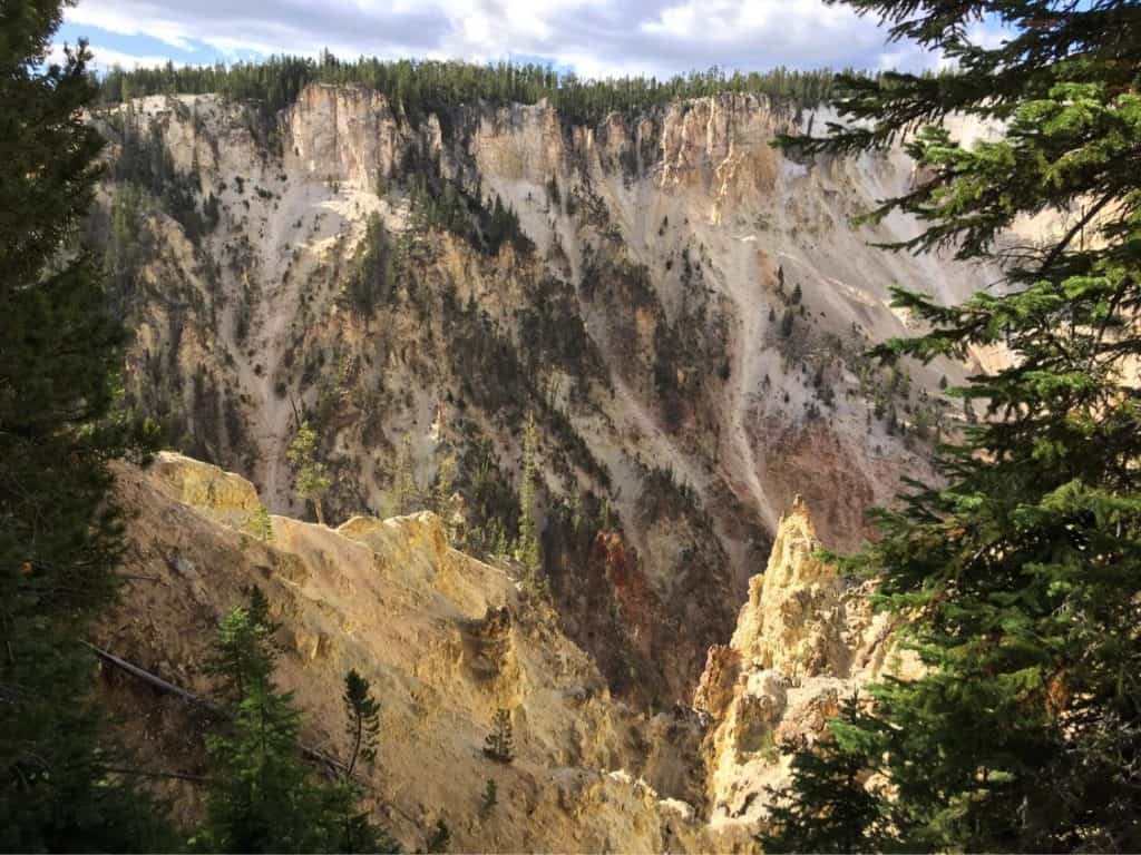
Then the bears pulled more and more into the woods in front of the curious people, but as we approached,an awful-sized grizzly stood up from behind one of the bushes. The sight of this commanded everyone to stop. We stopped there too and watched the teddy bear for a while, then turned back to the car and continued on the journey of discovery. It was a very good start in the park. We decided to tour the Grand Canyon of Yellowstone Park today, the Grand Canyon of Yellowstone. We first looked at the right side of it by driving to the end and then stopping back everywhere. The end of the highway opens into a car park where the view is actually most beautiful. From here it is only a walk away, several tens of miles of
hiking trails, where according to the sign it is not recommended to go alone or start without a bear spray.Some of the bears that live here are grizzly, which is far more aggressive than their black relative.Although I think I would meet any of them more closely on my own, I would rush back to the car in chocolate pants. But now we are not affected by this part of the park, this time we just came to see the sights. But we have arrived at the best place, because the canyon has the most beautiful view from here,as you can see the canyon from here in length. Here it becomes clear where Yellowstone, or Yellowstone Park, got its name, as it is beautiful to see several shades of yellow cliffs everywhere, and at the bottom of
the canyon the Yellowstone River rushes. For the sake of this sight, it was already worth taking this long
journey. The approx. after a million photos we took here, we walked slowly back to the car
Dying backwards in the car, the passengers noticed a bear again,and then we walked towards the bear here too, so that we could take the best possible photo of it, of course from a decent distance, until we disturbed it. But we soon continued on our way to the waterfall we saw in the canyon at the first lookout. Then, bypassing the canyon, there is also a lookout in the immediate vicinity of the waterfall, from where we looked at the waterfall. We set out to explore this side of the canyon and went out to take photos and videos at every possible stop and it went all the way to the end. The sight of this could not be satisfied.We wanted to see every detail of this yellow miracle. Then the evening came slowly and my little tent partner and I set up to set up our tent while the other half of the team returned to Cody and stayed in our old motel. Our campsite was in a forest where a caravan or motor home (RV, motor home) could not enter. The tent sites were a fair distance apart and came with a bear-safe iron box in which you could keep your food. I put my Borsod beer in it, for sure. Of course, food was added later, he couldn’t stay in the tent or outdoors. I was just holding a lamp, a bear spray, and all sorts of defense tools around us if we were to walk like last year, the man the bear took out of the tent. The night was very bad. It was weird to sleep outdoors, I haven’t camped in years, and it was as cold as if we were in Transylvania. I felt like I wasn’t sleeping. I wake up to every little ness. Then one morning, when my “roommate” came out of the tent, he shouted back, “Tibi is out, a tailor is sniffing around the tent.” By the time I got out, he was already at our stove running from stove to stove after smelling leftovers. Csabi was just making breakfast when the rest of the team arrived and they joined us for breakfast. So we had time to discuss the daily program and get back to ourselves a little after a little sleep. We decided to set out today to explore the geysers.
We visited a beautiful geyser land where there is no sign of life,everything is deserted, sheer, yet beautiful as a porcelain plate. It is also the name of a part of this landscape, the Porcelain Basin, which is part of the Norris Geyser Basin near Norris, where the famous Stemboat geyser is located.
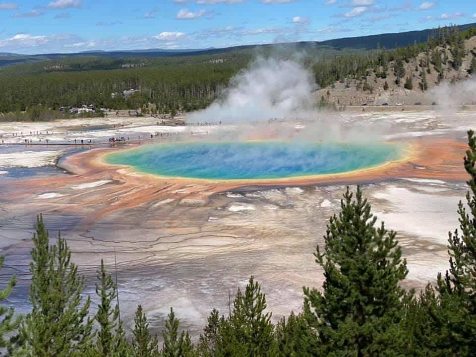
A geyser field can be walked around on a wooden promenade. We even set off, and the first geyser we saw burst was just a strain, rising barely 20-30 inches,rather like a little spit compared to the others that came next. Of course, we were happy about that at the time, because we didn’t know if we’d see an erupting geyser at all. Then the next time we saw maybe half a meter away, we finally saw a fairly acceptable scale of approx. two to three meters. When we were satisfied with this place, we headed for Madison and, leaving Gibbon Falls, headed for Madison at the Madison intersection, deviating from the main road after Madison and continuing on a narrow one-way road toward Firehole Falls. This little detour is worth every minute spent here. We stopped here, dived a little into the Gibbon River, and after a short rest we reached the Midway Geyser Land, where the Grand Prismatic Spring is located. The crowd was huge here, but I finally managed to find a parking lot and catch up with my passengers at the prism who got out of the car because they didn’t want to wait for parking. The sight of this prism was stunning.
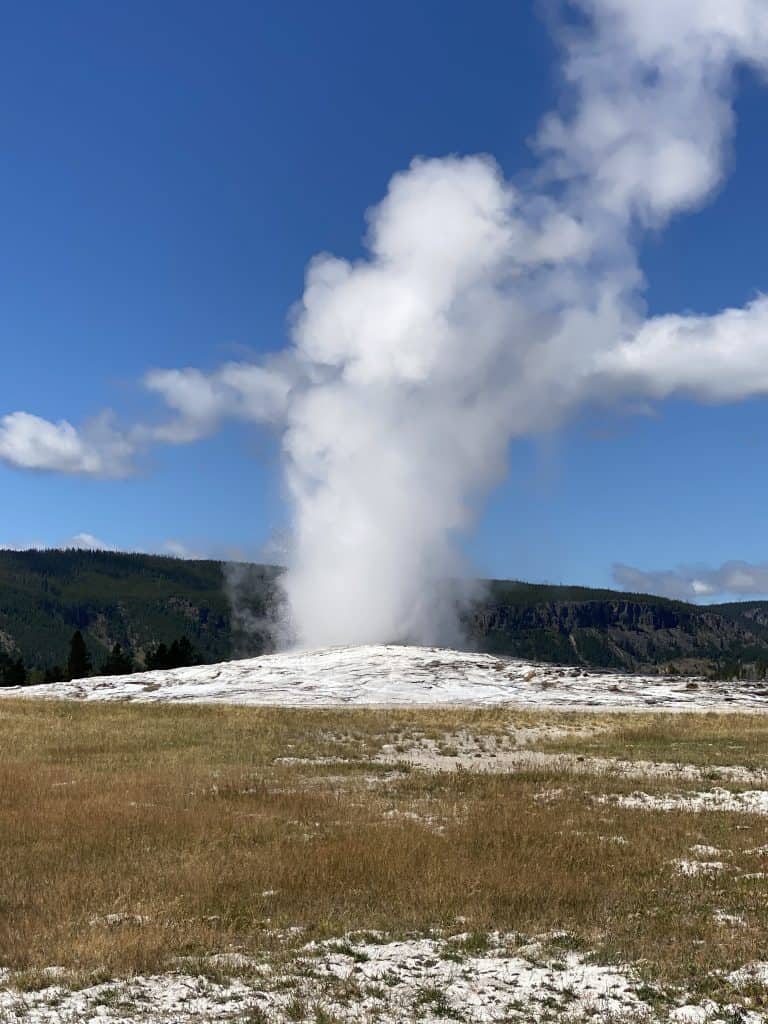
Wonderful. Words are hard to find, as I haven’t seen anything like it before. I haven’t even gotten there,but I’ve already seen the almost 8O-degree water flowing out of the hot prism flow down the hill into the Gibbon River, and then the walkway leading to the prism can be approached through the walkway across the river. The first such attraction here is the pre-Prizma hot water pool, which ultimately provides hot water to the Gibbon River. This pool has a beautiful blue color and includes several types of blue. The Prizma, which has several colors, is surrounded by a brown floodplain of yellow,red, green and blue. The prism and brown floodplain, as well as the colors of the hot springs and pools around it, are created by the bacteria and microorganisms that live in it. You can walk around this, but due to the size of the prism from the promenade you can’t see it like in the photos, it’s impossible to see the whole prism like that. It takes a little hiking to see it, so the next stop on our way was this location. As we left the prism parking lot, the next parking option was the location of the hiking trail that led up the mountain. We also took a short tour of him, which was a round-trip walk of about an hour. Here, following the crowd, we went up the mountain, where you can see the Prism from a kilo. The little footpath was completely worth it, as seeing it all, it looks like a huge eye staring at the sky without blinking. Once we had the right amount of photos and videos, we headed to Old Faithful. When we arrived at Yellowstone’s largest geyser, it had just erupted, so we could rush out of the parking lot to admire the huge, multi-storey natural fountain. We couldn’t even decide whether to video or take photos.
When the show was over, we also toured its surroundings and then went to a tent site called Grand Vilage in the direction of West Tumb, which is on the shores of Lake Yellowstone. Wonderful environment,much less trees, we found ourselves in a clearing where caravans and caravans can already be parked. I housed the team in West Yellowstone where we bought another deer / bison burger and then we went back to camp to set up our tent even more clearly and the rest of the team left us there in the park. Here we went down to the shore of the lake at dusk after a walk, admired the lights, and then walked back to camp. There were so many mosquitoes that you could barely eat them, you caught a mosquito with almost every bite, so I preferred to give up eating. We set up a campfire, burst into bed, then talked at length,resting after midnight. But this night was no better than the previous one. The cold didn’t let him sleep now. The team arrived in the morning, and after a little breakfast and tent-breaking, we said goodbye to the world’s first National Park to approach Grand Teton National Park, which is to be approached at the south exit of Yellowstone. On the road 89/191/287, we reached Lake Jackson, on the other side of which are huge snowy cliffs. But unfortunately the weather is bad and due to the rain we couldn’t take good pictures.
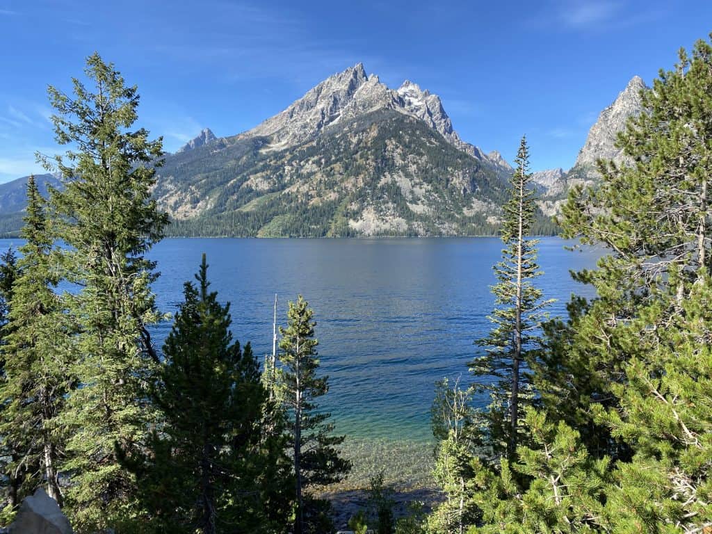
Teton Grand Teton National Park is almost the beautiful little brother of Yellowstone. The two parks may be 45 minutes apart, but to me, Teton looked much prettier than Yellowstone. With its huge snowy cliffs in front of it, the clear blue lakes form a phenomenal picture. Holding our breath, we admired the underworld and the dimensions. Turning out at the first tourist center, or the Colter Bay Visitor Center,we bought ourselves food, coffee, some small souvenirs, but mostly maps. Then we drove off at the most beautiful place in the park, turning out at Jenny Lake. It’s good to know here that if the parking lots are full, it’s worth the wait because parking along the roads is forbidden, there’s a penalty for it, but the view is too nice to miss. We stopped to watch, but due to the bad weather, the sight was broken, but it was still fantastic. But we didn’t even dedicate any more to this park because it was too not enjoyable, so we headed to Jackson City. Unfortunately, the weather is still all day long and has left its mark on the wild western atmosphere of the small town. To our greatest regret, we couldn’t even see it properly, so we headed home.
We drove not far from Jakson to the place where Hugh Glass lived, who was brought to life by Leonardo DiCaprio in his film The Revenant in 2015. On the way home in Wyoming, more and more storm clouds were gathering in front of us so much that we were heading east on a high plateau on I-80 as we reached the mountains in front of us into a hail that wethought would wash us off the road. We could barely drive our car, but we didn’t want to stop. There were no barriers along the way and if we had slipped, we would have been spinning down a mile before something stopped us. So I reduced our speed to about 20 miles and moved on with a stall. There were huge trucks overtaking us, but I was already thinking about going out the first exit, as about a foot (about 30 cm) of ice had accumulated on the road and it was not pleasant to drive uphill, especially since the melted and ice rumbled like a stream down the tracks of the wheels on the highway. But the team decided to go further, not go out the exit, and I could see it slowly slipping out from under the cloud, so that the wheel squeezed so that the wheel would in no way turn right or left, if it slipped, we would move slowly. But the weather wasn’t clear, it got worse and by this time we were already going down the hillside and were afraid we would slip. Meanwhile, the landscape turned white, as if it were winter. We were still driving for almost half an hour when a huge black cloud approached us on our left, but luckily it no longer reached us, and so we got out of the storm pretty slowly. If we set out to rest, we know how long we would have stood in the hail.
When we left the icy landscape, we were able to drive at full speed again and we were no longer far from Cheyenne, and then I remembered from 2002 when I was walking there, there was a little pie next to the highway with a little park, which is very interesting. This is called Tree Rock. I stood at the restroom to show my fellow travelers something. Here I showed them a place where a huge stone had split in two from which a pine tree had grown. A sign informs us that when the railway was built between 1867-69 (see Hell on Weels) they had to move this stone a little further. This pine tree has been growing from this stone ever since. The former train station was also here and the train firefighter drank this tree at every stop. Then in 1901, the railroad moved a few miles away, and from the site of the former railroad it became a road and then a highway. The tree is still here. This type of pine can live up to 2OOO years. We soon arrived at our hotel where we occupied our room. I went down to the hotel’s swimming pool, where no one had a mask because of the covid epidemic, which I wasn’t so surprised at, as we could barely see anyone in a mask west of Chicago almost all the way. Then I immersed myself in the pool to swim and in
the meantime I took a bad breath and sucked some water into my lungs so I started having a strong cough.
By the time I opened my eyes, everyone ran into a corner of the pool, then slowly got out of the pool and went up to my room, leaving them to feel good. We ordered pizza with our companions and we went to sleep. The next day, nothing to mention was done, except that my phone was already catching the 5G system in the wilderness of Nebraska, Pennsylvania where I live there was no sign of the new network yet. In the evening we arrive in Joliet, a small town before Chicago, where we stayed in a hotel that turned out terrible choice. Then the next day we got home to New York.